[Note from editor: we are looking to create a more extensive Local History section to the website - please let us know if you have any photographs of village life pre-1950]
Cuddington and Sandiway are situated on an undulating plateau of sand where the ground rises from the Weaver Valley at the northern border of the Central Cheshire plain. This plateau of sand stretches from Mouldsworth through the Delamere Forest valley and ends in an abrupt bank running from Kingsley to Cuddington about 200 feet above sea level. It was probably left when the glaciers began to retreat at the end of the Ice Age, 12,000 years ago.
The depth of sand varies but in an unsuccessful search for water near Cuddington station in the 1880s, the sand was found to be at least 60 feet deep. More recently abundant Molluscan shells, presumably from the Irish Sea, were found at Daleford sand quarry (now Cemex). They date back some 28,000 years.
Although no archaeological finds of any period have been recorded within the Cuddington and Sandiway boundary, a Bronze Age burial ground in Norley, Iron Age Hill forts at Eddisbury and Oakmere, evidence of the ancient highway of Peytefinsty, linking Weaverham with Tarporley, and the long, straight roads of the Roman legions, are testimony to the fact that man had trod these paths for thousands of years.
By the 11th century the vast Forests of Mara and Mondrem covered the whole area, extending to over 60 square miles, stretching from the river Mersey in the north, to Nantwich in the south, and from the Gowy in the west to the Weaver in the east.
Within clearings in this ancient woodland the first settlements that can be named Cuddington and Sandiway gradually appeared. It was in Anglo Saxon times that Cuddington was given it's name, 'the Tun (town) of the people (or farm) of Cuda'. Sandiway was, at this stage, merely a 'sandy way'.
However, until 1935, Cuddington and Sandiway were completely separate communities with Bryn Common in between.
For many years the tiny population in Cuddington and Sandiway were poor, sparsely spread farmers and cottagers living as best they could off the land. A cottage meant a one room mud hut with leaves laid on branches for a roof or a humble timber framework filled in with mud. Heating and cooking were by bonfire on an earthen floor. The peasants main source of meat was from pigs which fed on acorns from the forest, poultry and fish caught from the meres and streams.
In the 7th Century the parochial system was introduced by Theodore, Archbishop of Canterbury and Cuddington was designated to be within the parish of Weaverham.
In the eleventh century Domesday Cheshire was divided into 10 hundreds. Weaverham (and thus Cuddington) was contained in the hundred of Roelau. which was amalgamated with Risedon to form the Eddisbury hundred.
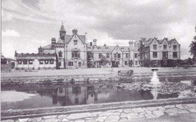
Vale Royal Abbey [our thanks to CC Publishing (Chester) for permission to display]
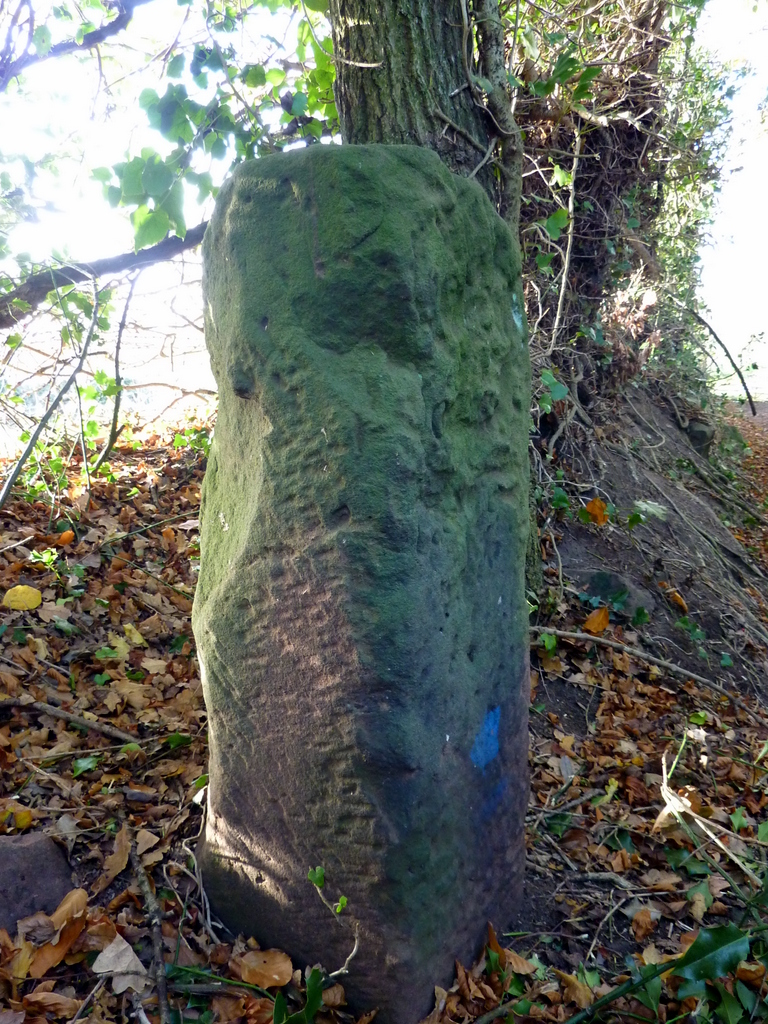
By the late thirteenth century Sandiway also formed part of the possessions of Vale Royal Abbey, built in Whitegate in 1277. The Toolerstone, situated on Hunt's Lane, off Weaverham Road, marked the boundary between Cuddington and Sandiway.
The Toolerstone
The Abbey was erected by Prince Edward (Later Edward 1) and was run by its Cistercian Abbot and monks as a ruthless enterprise using armed force to collect tithes. Their grain stores (Granges) and farmsteads appeared throughout the locality. Hefferston Grange (between Cuddington and Weaverham) and Earnslow Grange on Whitegate Lane, Sandiway still stand and Toolerstone House on Norley Road is thought to have been one of the Abbey's farms. After Vale Royal Abbey was destroyed in the sixteenth century, during the Dissolution of the Monasteries, it was replaced by the great house of Vale Royal built by Sir Thomas Holcroft.
In the fifteenth and Sixteenth centuries Cuddington was still part of the forest and subject to its harsh laws whereas Sandiway was divided between the parish of Weaverham and, until 1540, Vale Royal Abbey. The Abbot of Vale Royal refers to the tithe at Weaverham as not being worth 'more than 12 bushels of wheat.....most of the land is sound (sand ) and will bear no wheat.' There is evidence that our village provided a quantity of timber (usually oak) for building and repairs in other parts of the county and further afield.
In the mid eighteenth century (1766), in the interests of efficiency, it was necessary to enclose the common lands of Cuddington and Bryn, some 460 acres, in order that it might be ...'cultivated and improved and rendered of some use and value...' The Common was to be enclosed with the exception of the roads and 11 acres for the obtaining of marl, clay, sand, stone and gravel for repairing private and public roads. Also exempt were Town Moss (one acre) and Cartlidge Moss (three acres) for the cutting of 'pete' and turf by every inhabitant, in addition to Flea Moss Pits for water. The enclosure of Gorstage and Sandiway was included in the Weaverham Enclosure Act of 1794.
The single event which impacted on Cuddington and Sandiway more than any other was the coming of the West Cheshire Railway in 1869. To house and serve its workers brick dwellings, businesses and shops began to spring up along Warrington Road (the A49) and in 1874 a Yorkshireman, William Horner, moved his creamery from Weaverham to Cuddington. This factory was to go from strength to strength. WW2 saw the firm processing millions of gallons of milk a year and at its peak, when production changed to yoghurt in the 1960s, employing up to 250 people. Cuddington's centre had always been Upper Cuddington or 'up top' , the group of farms and dwellings near Delamere Park, but with the arrival of the WCR the village centred around the intersection of Norley Road and the A49 (The White Barn Corner).
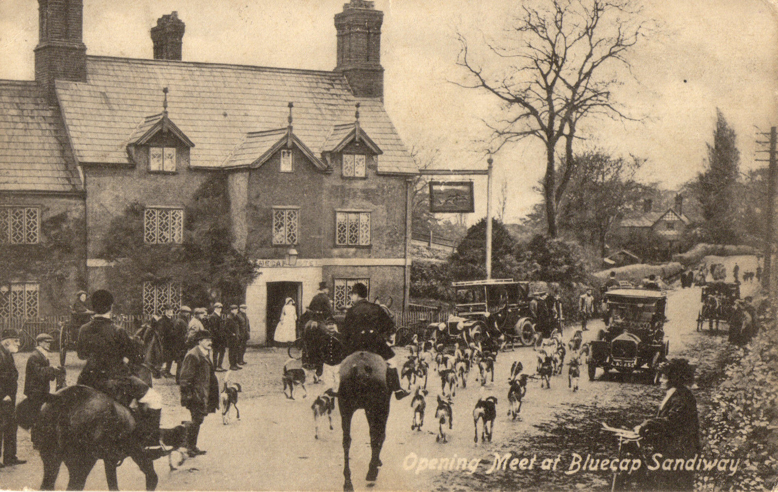
Another important factor in Cuddington and Sandiway's development was their proximity to excellent game hunting and the attraction of Tarporley Races.
Opening Hunt at Blue Cap Hotel [our thanks to CC Publishing (Chester)]
For many years The Blue Cap Hotel, on Chester Road, was the Open Meet for fox-hunting in Cheshire. The fox hounds are still cared for at the Kennels in Sandiway. Whatever our feelings about fox-hunting, this was the magnet that led to the building of many of the large houses in the district which began in about 1780 when George Wilbraham built Delamere House in what is now Delamere Park.
Around the turn of the twentieth century the ever present attraction of fox hunting and the convenient railway links to Chester, Manchester, London and Liverpool meant that there were more large houses, wealthy businessmen and members of the landed gentry per acre in Cuddington and Sandiway than practically anywhere else in the county.
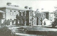
Cuddington and Sandiway's famous son. the outstanding Cheshire architect, John Douglas, was born in the village at Park Lodge (now Littlefold) in 1830 and was responsible for the design of many of our grander houses including Abbotsford on the A49 and Sandiway Manor and Forest Hey on Norley Road. Our village is also indebted to the Thompson brothers, Northwich businessmen who financed the building of Merlewood, Beechfield, Abbotsford and Cuddington Grange.
Delamere House, mid 19thCentury [our thanks to CC Publishing (Chester)]
The National Censuses of the nineteenth and twentieth century's show an increase in population which more than doubles in the former and increases tenfold in the latter. Bagshaw's Directory of 1850 says that in 1841 Cuddington had 52 houses and 253 inhabitants. The principle landowner was George Wilbraham at Delamere House. 1874 Morris and Co's Directory gives Cuddington's population as 370 inhabitants and shows a greater variety of trades in the village including 4 millers (timbre and corn), a blacksmith, coal merchant, stable keeper, rate collector, postman, publican (the White Barn), pig and hay dealers, 2 gamekeepers, a wheelwright and 9 farmers. In 1892 Kelly's Directory gives the population at the 1881 census as 408.
In 1936 part of Weaverham Civil Parish was transferred to Cuddington Civil Parish which is indicated by the tremendous leap in population from 402 in 1931 to 2,898 in 1951. Archbishop Theodore's legacy had lasted for 1.200 years. From this moment the communities of Cuddington and Sandiway came to be merged into one ecclesiastical and civil parish.
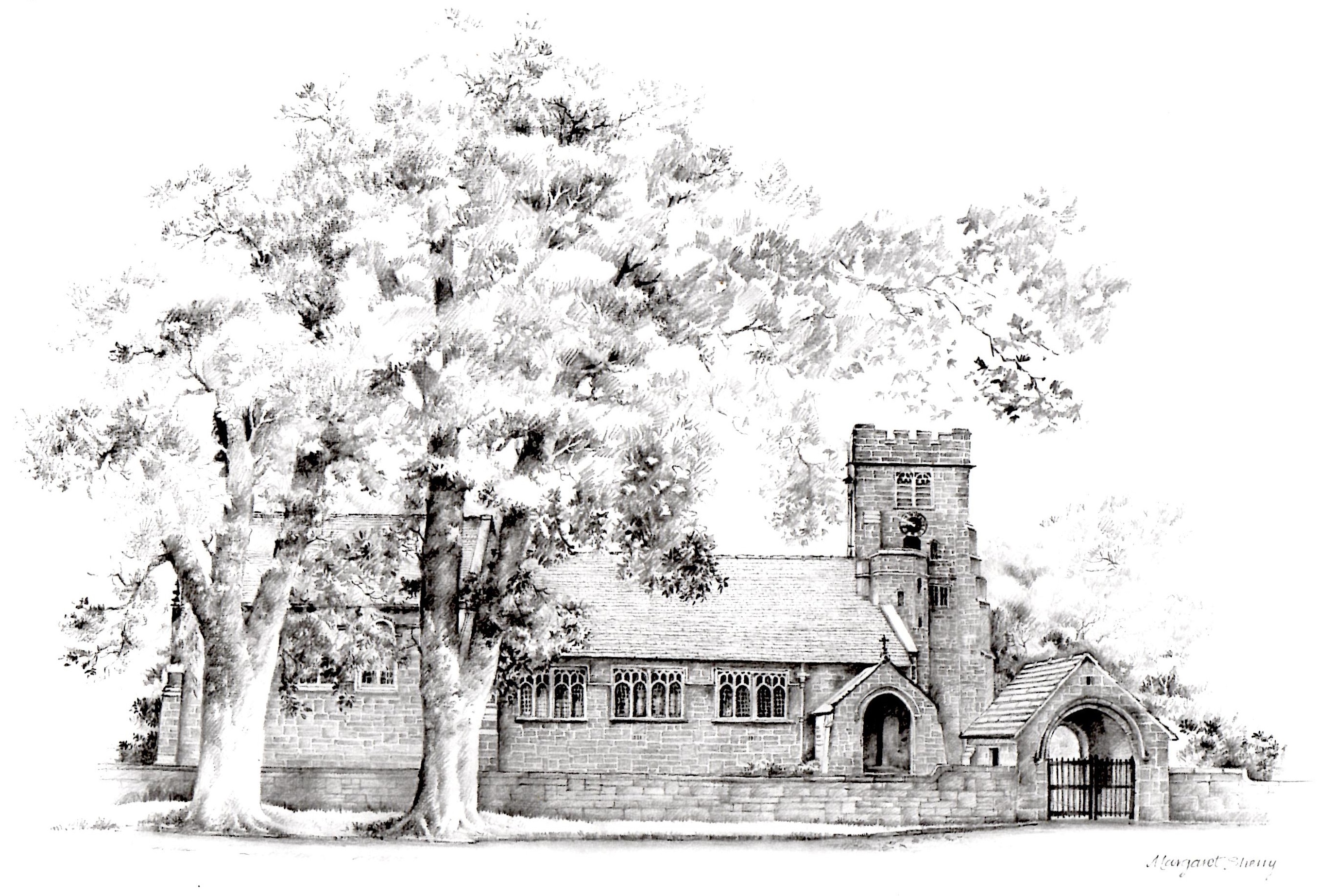
Drawing by Margaret Sherry, Churchwarden, St John's
The foundation stone for Sandiway's own church, St John's, had been laid in 1902 but it was not fully operational until the 1930s. when the Rev. Joseph Barnes Horrocks was appointed the first vicar. In Sandiway the Forest Wesleyan Methodist Church was built in 1878 and The Bryn Primitive Methodist Chapel, opened in 1819. The Cuddington United Methodist Chapel was established in 'old' or 'upper' Cuddington in 1849 to cater for the spiritual needs of the farmers and cottagers of the locality.
In 1950 began the development of Bryn Common. The Council Estate was built and it's Mere Lane shops opened in 1952. This was followed by the Wimpey Estate based on Bridge Farm in Cuddington and the Locke Estate and East Lane got underway in 1965. Planning permission was granted by Northwich Rural District Council for a self contained village of executive houses and in the early 1970s Whelmar Homes proceeded to develop the modern Delamere Park.
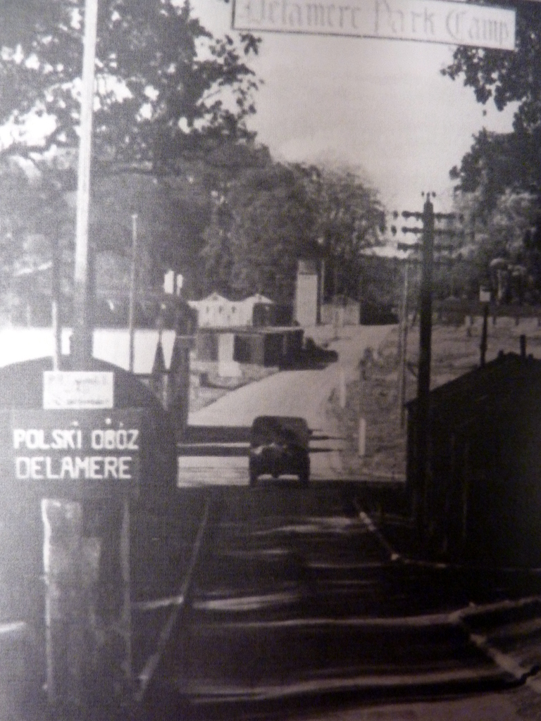
In 1938 Captain George Wilbraham, the owner of Delamere House, held a three day sale of 800 lots which brought down the curtain on Delamere House. Captain Wilbraham built himself a new home, Delamere Manor, which was situated outside the park. In 1939 WW2 began and the old, empty parkland was taken over by The Pioneer Corps. What remained of the old house was demolished, roads were built, army barrack huts erected and the name, "Delamere Transit Camp", or Delamere Camp", was born.
Polish Displaced Persons' Camp at Delamere Park after WW2 [our thanks to CC Publishing (Chester)]
Eventually there were 15,000 American soldiers camped at Delamere Park and, it is alleged, General George Paton visited to meet the officers and frequently enjoyed a drink in the Blue Cap. Certainly, an eye witness account relates how, in the Summer of 1944, some days before 'D' Day, General Montgomery and General Eisenhower, who was in charge of the overall operation met at Delamere Park and there was a grand march past of all the troops. 'It was the most impressive sight ever seen in Cuddington: all the bands playing, the flags flying and the troops marching and counter-marching past the saluting base.' (Cuddingtonand Sandiway: The History of two Cheshire Villages. Edited by Frank A. Latham 1975)
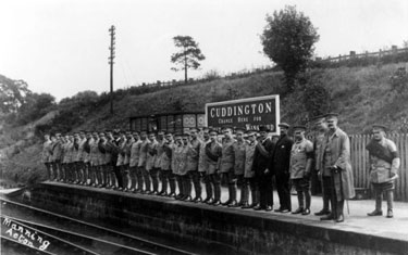
Soldiers at Cuddington Station during WW1 [our thanks to CC Publishing (Chester)]
In 1948/49 the army huts were adapted for temporary housing accommodation for people on the rural council's housing list, principally former servicemen and their wives and children. As many as 400 families, three quarters of them British, at one time lived on the old camp, waiting for completion of the council estates in Cuddington and Sandiway, Weaverham and Barnton.
By 1984 there were new housing developments established at Delamere Park, Forest Close, Windsor Close, Park Crescent, Primrose Hill, Cotswold Close, Chilton Close, Ivy Drive, Cheryl Court, Moorlands Avenue, Moorlands Park and Meadow Close, Greenfield Way, Lyndsey Walk and Green Walk
By 2001, St John's Way and Church Rise had appeared (off Hadrian Way) and the Jones Homes' estate (off Chester Road) added to these infills by 2005. The Eden Grange (on the former William Horner's Creamery and Eden Vale site) and Forest Edge (between Ash Road and Chester Road, and near the Shell Garage) estates were completed around 2018. The Eden Grange estate incorporates allotments which are for the benefit of the whole community - at present there is a small waiting list.
The Office for National Statistics told us that, at the 2011 Census count, the combined villages had a population of 5,333. The latest 2021 Census confirms a combined population of 6,196 (16% increase since 2011) with a split of:
Aged 15 years and under 1,144
Aged 16 to 64 years 3,422
Aged 65 years and over 1,630
Our thanks go to Mark Bevan, CC Publishing (Chester), as well as to Jill & Roger King for the assembly of this History section